Following the collapse of the Kakhovka Dam in southern Ukraine, one of Europe's largest reservoirs is now drying up.
Four canal networks have disconnected from the reservoir, according to satellite images analyzed by BBC Verify.
More than 700,000 people, mostly in Russian-occupied areas, could have their drinking water supplies impacted, according to the UN.
According to experts, the region's ability to produce food depends on the amount of water that is lost through the canals.
In the early hours of June 6, the Kakhovka Dam was destroyed, which resulted in widespread flooding that hit farmland and settlements throughout the area.
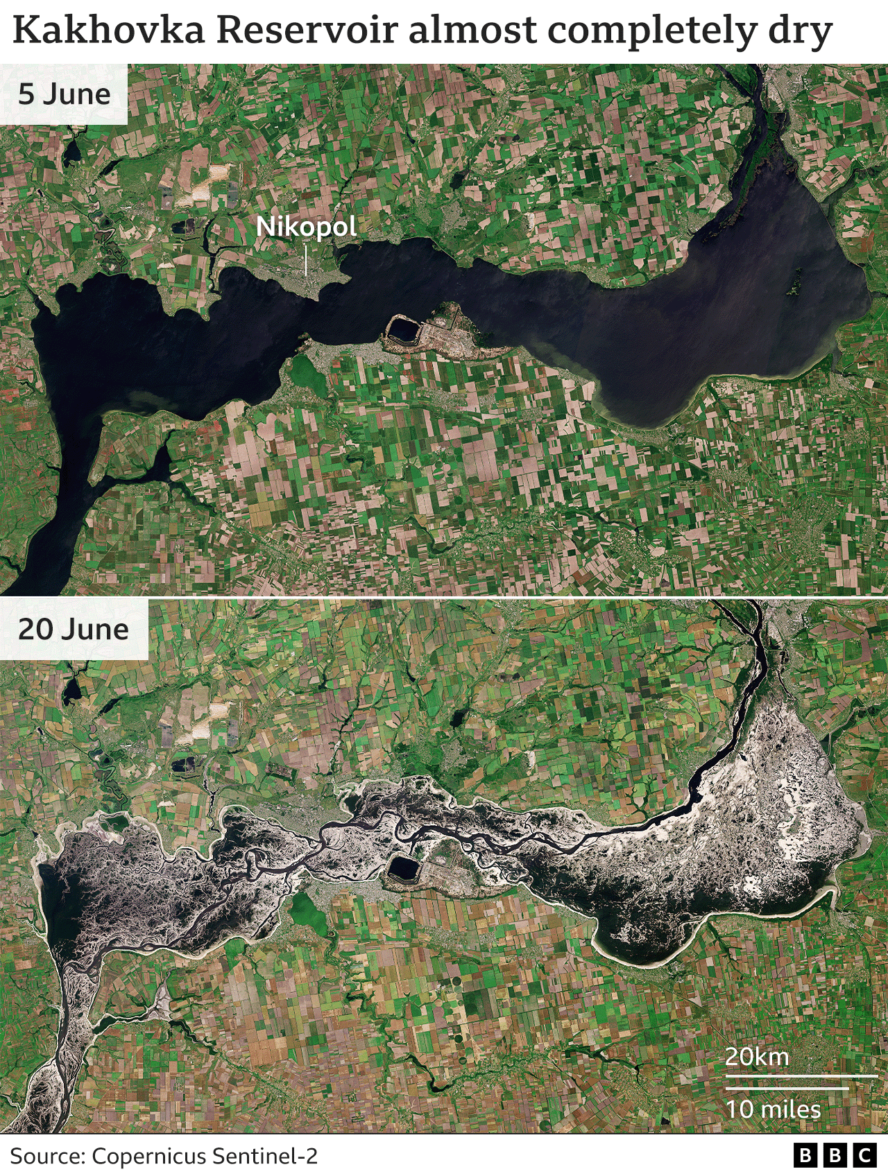
Water levels significantly decreased in the reservoir and the canals it feeds upstream from the dam (to the northeast). As seen in recent satellite images, levels have continued to decline.
The canals supplied irrigation for huge tracts of farmland in addition to serving as a source of drinking water for much of southern Ukraine. For areas downstream and to the southwest, the dam served as a flood defense.
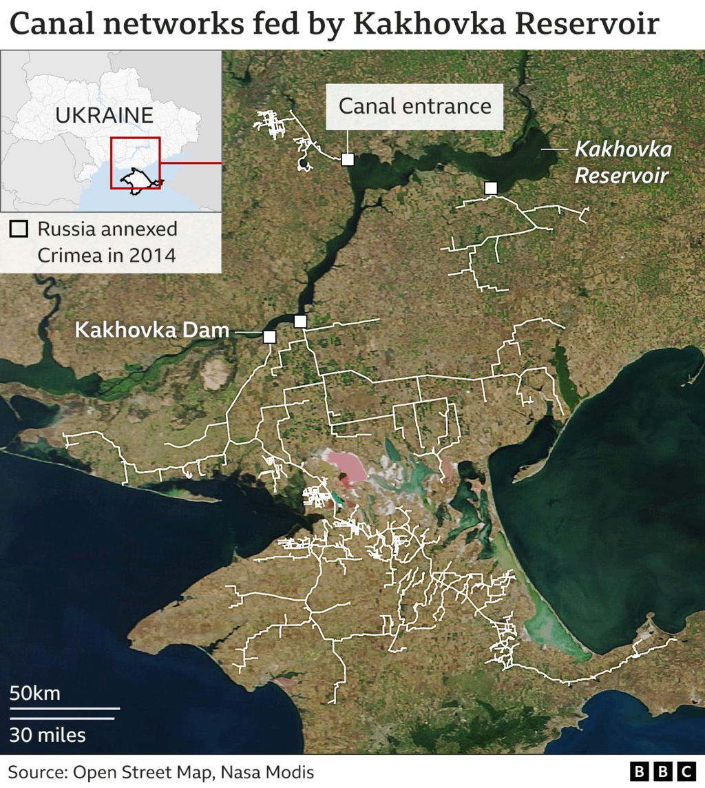
By the 15th of June, BBC Verify had stopped using satellite imagery to monitor the four canal entrances because the reservoir water level had continued to fall.
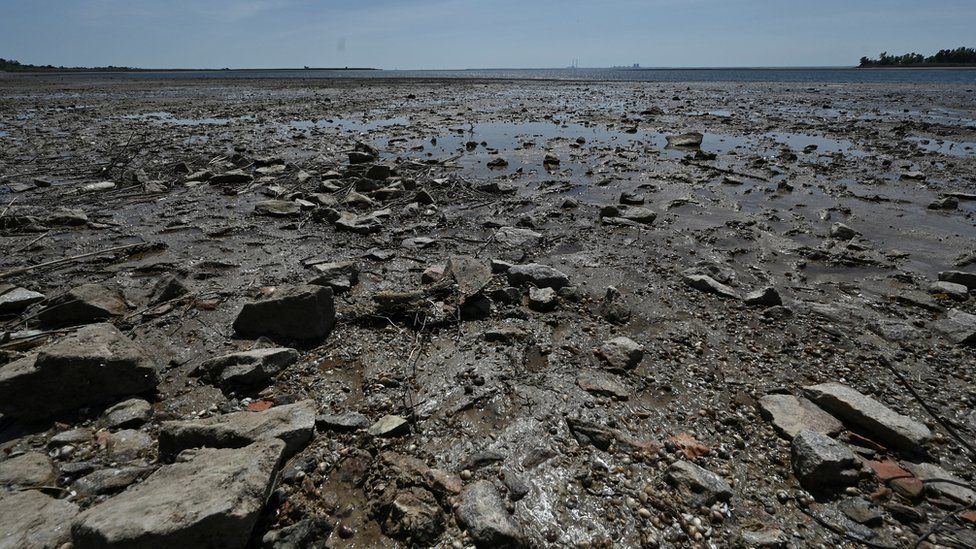
The reservoir, which once held 18 million cubic kilometers of water, can be seen to have significantly dried up in additional images.
The Dnipro River's pre-dam shape was partially revealed when the reservoir's shallower sections were first exposed in 1956.
Images demonstrate that the canals still have water in them farther away from the reservoir. It is unknown how long it will be before they run out.
Approximately 5,840 sq km (584,000 hectares) of cropland could have been serviced by the canals on both sides of the Dnipro river prior to the war, with more than half of the area dependent on irrigation systems.
The Ukrainian government estimates that these areas produced about two million tonnes of grain and oil seeds in 2021.
After the dam was destroyed, many areas downstream of the reservoir were initially inundated; however, Inbal Becker-Reshef, program director at NASA Harvest, a group that studies global food security, says that the long-term problem facing food production will be the loss of water supply due to extensive canal systems drying up.
"Crops planted in the summer, like corn, soy beans, and some sunflowers, are primarily irrigated by the canals. But they also irrigate a lot of melons, as well as some wheat, which is a winter crop, she added.
Even though some crops can be sustained solely by rain, a dry canal system can leave farmland susceptible to drought, which has an impact on drinking water.
Canals can begin to fill in with silt if they are left dry, decreasing their effectiveness. The longer they are left in this condition, the worse they will get, according to Dr. Becker-Reshef.
According to Martin Griffiths, the head of emergency relief at the UN, the dam's destruction would have a "huge impact on global food security," calling the region "a breadbasket not only for Ukraine but for the world.".
Sunflower, maize, wheat, and barley are among the main exports from Ukraine. Given how heavily Middle Eastern and African nations rely on Ukrainian grain, the war has threatened supplies all over the world.
One of the only lasting solutions to reestablish water security in the region appears to be to rebuild the dam.
Since the water level has dropped, the [canal] systems cannot receive water. Mykola Solskyi, Ukraine's Minister of Agrarian Policy and Food, stated that in order to raise it, the dam must be rebuilt.
Because the dam helped control extreme highs and lows in water levels, experts warn the region is more vulnerable to both drought and flooding.
Jaap Flikweert, a flood and coastal management advisor at engineering firm Royal HaskoningDHV, stated that a large portion of the river's downstream catchment is currently uncontrolled. Flood waves will simply come through during the wetter times. ".
Some areas may prove unsuitable for settlement because they lie so close to river level, according to Mr. Flikweert, unless the dam is repaired or extensive flood defences are put in place.
"I anticipate that the tens of thousands of individuals who were evacuated will need to remain elsewhere for some time as long as those solutions are not implemented. It is difficult to imagine residents of those communities returning given the current circumstances. ".
More information about BBC Verify can be found at Defining the "How" of BBC Verify's Launch.